Hiking in Acadia National Park is an extraordinary experience. The Park maintains about 135 miles of beautiful and interesting paths and trails, ranging from the easy to the strenuous and even perilous. Many are memorial paths. One of the latter is the Homans Path. Its entrance is located in the Sieur de Monts Spring area near the junction of the Jesup Path and the Hemlock Road.*1
 |
| Homans Path entrance |
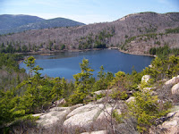
The path is named for Eliza Lee Homans. In 1908 she gave the first large gift of land to the Hancock County Trustees of Public Reservations. It consisted of 141 acres and included The Bowl and The Beehive on Champlain Mountain, two popular hiking destinations today. At the time, the HCTPR was attempting to acquire land on Mount Desert Island for protection from development and for preservation for public enjoyment. It is interesting to note that Eliza, in giving this property, reserved the right to keep a boathouse on The Bowl, a 10-acre pond, and specified the Beehive Mountain Aqueduct Company would continue to use the pond to provide water to nearby residents. No sign of the boathouse is evident today and the BMAC no longer exists.
 |
| The Bowl |
 |
| The Beehive |
Eliza was born in 1832 in Dover, NH, and in 1856 married Charles Dudley Homans. Charles, born in Brookfield, MA, in 1826, graduated from Harvard in 1846 and was a physician and a president of the Massachusetts Medical Society. They lived at the "Homans Cottage" on property abutting the south side of the Schooner Head Overlook, 3.8 miles south of Bar Harbor's village green. Charles died in Bar Harbor in 1886; Eliza died there 28 years later. Both are buried in Mount Auburn Cemetery, Cambridge, MA.
 |
| Mt Auburn Cemetery |
The highly crafted, stone-stepped Homans Path has a mysterious history from the 1940s, when it ceased to appear on maps for over 60 years. Built in 1915-1916 shortly after Eliza's death, the path last appeared on the 1941 Path and Road Map of the Eastern Part of Mount Desert Island, Maine and did not reappear until indicated on the 2005 Acadia National Park map. The Park "reopened" it in 2003 as part of the Acadia Trails Forever project, a joint effort of Acadia National Park and Friends of Acadia to rehabilitate and restore the Park's trails. In October 2006 the path sustained damage from an earthquake but was successfully repaired and reopened the following year.
 |
| Homans Path |
It is a magnificent path to experience and not soon to be forgotten. It consists of granite steps, passages and overhangs on its 0.33 mi length. Its vertical height is 328 ft and should be considered moderately strenuous. Once at the top hikers can continue on to the 1270-ft summit of Dorr Mountain via the Schiff Path or return to Sieur de Monts via the Emery Path or the Kurt Diederich Climb, three other stellar memorial paths.
 |
| Homans Path - aerial view |
Postscript: ANP treats trails and paths differently, with the latter showing significant human engineering, such as the addition of steps, staircases, and iron ladders and handrails. It also respects the historical names originally applied to these paths by their benefactors and builders.
*Footnote:
1 Homans Path entrance GPS coordinates: N44° 21.780' W068° 12.549'


