For something different I thought I'd recreate an old walk from the Bar Harbor village green to Acadia National Park's Sieur de Monts area, the latter being a popular destination from town during the formative years of the Park in the early 1900s. It is a mostly flat, 5-mile loop. Along the way you'll pass memorials and trail markers, while enjoying interesting sights in Bar Harbor and the Park. There are restrooms at Sieur de Monts. As with all woods walks, bring drinking water and bug repellant. Hats, cameras and binoculars should also be taken. Note: Portions involve walking on the edge of streets.

Make a left turn onto Kebo St (Lime). Notice on the southwest corner a stone with a memorial to Philadelphian DeGrasse Fox, an early developer of Bar Harbor. Proceed along Kebo St and at the intersection cross Cromwell Harbor Rd. The large stone on the southeast corner has the words "Jesup Path," a memorial path in honor of the Jesups. Stay on the Jesup Path (Blue)--also called here the Great Meadow Loop trail. In a short distance the path ends. You will have to walk on Kebo St, crossing over Kebo Brook. The fairways of Kebo Valley Golf Course, the eighth oldest golf course in the U.S., are on both sides of this street. Rejoin the path in front of Holy Redeemer Cemetery. As you walk along the path, you will see the remnants of an old quarry on your right. Just beyond this point, cross Kebo St and reenter the Great Meadow Loop trail. A short distance ahead bear right at the trail post for the Jesup Path, descend the stone steps and cross the Park Loop Rd. Enter the Jesup Path. Get your binoculars ready, as this is the Great Meadow, a good venue for warblers.
Stay on the Jesup Path through the Great Meadow until it meets the gravel Hemlock Rd (Orange). Follow the Hemlock Rd to the right -- do not enter the Jesup Path boardwalk. You'll pass a trail post on the right and an engraved stone with the words "Strath Eden Path," an 1890s path out of Bar Harbor, which was officially called Eden until 1918; strath is Scottish Gaelic for river valley. Continuing on the Hemlock Rd you'll pass a trail post on the right with the words "Homans Path" (see an earlier blog article). Turn right just after it and rejoin the Jesup Path (opposite the boardwalk). Cross the wooden bridge and in a few feet turn right at the Jesup Path trail post.
On the right you'll pass stone steps and a trail post for the "Emery Path," a memorial path to Cincinnatian John Emery, who built the massive granite Turrets cottage in 1895 on what is now the College of the Atlantic campus. To your left is the white Sieur de Monts spring house; Bostonian George Dorr, the "Father of Acadia National Park," purchased the land in 1909 to preserve the spring. Continue straight ahead and cross the rustic wooden bridge. On the right is the native-American Abbe Museum, founded in 1928 by New Yorker Dr. Robert Abbe who was likely the first U.S. physician to use radium for cancer treatment.
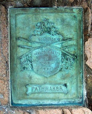
Cross the gravel road and continue to The Tarn, a pond in the process of converting itself into a marsh. Near the outflow are four memorials on the right. The first you come upon is the memorial plaque for the Jesups. The next is the engraved sixth step on the entrance to the Kurt Diederich Climb memorial path, a Marylander who suffered early tragedies. Just beyond it is a stone marking the start of the memorial Kane Path and a few feet beyond it is a memorial plaque to New Yorker John Kane for whom the path was named.
Return to The Tarn's outflow and cross the 10 stepping stones. Make an immediate left at the trail post onto the Wild Garden Path (Brown) and return to Sieur de Monts to the Nature Center building. You are now heading back to Bar Harbor. Behind the Nature Center is a memorial to George Dorr. Cross the wooden bridge in front of the Nature Center and at the entrance to the botanical Wild Gardens of Acadia. Make an immediate right at the trail post pointing to the Jesup Path and proceed straight until you come to the boardwalk. Take the boardwalk, which is the newly-rehabilitated Jesup Path, to its end and make an immediate right onto the Hemlock Rd. Continue along it, binoculars at the ready, to its end at the boulders and the Park Loop Rd.
Cross the road and turn right onto the Great Meadow Loop trail (Green). The golf course is on the left. Just beyond the path's bridge is Ledgelawn Ave. Cross it and reenter the Great Meadow Loop trail at the trail post. The trail returns to Ledgelawn Ave. Turn right and walk along the road until you reenter the Great Meadow Loop trail at the signpost and wooden bridge on the left. Continue on the trail. A cemetery will be on your left. Whistle, if you like. When you come to the boulders and Cromwell Harbor Rd, turn left and proceed to the entrance of Ledgelawn Cemetery. Just inside the cemetery to the left is the large, white horizontal gravestone of George McMurtry, who was awarded the Medal of Honor for his heroism with the famed WW I "Lost Battalion." Cross the road and enter Spring St (Red). Follow it back to Mt Desert St. Turn right and continue to this walk's end at the village green. Phew. You've earned yourself a delicious, locally-made ice cream!
For those interested in using GPS, here are the coordinates of the memorials and path markers mentioned:
1-Village Green fountain/horse trough: N44° 23.261' W068° 12.270'
2-Jesup Memorial Library: N44° 23.233' W068° 12.386'
3-DeGrasse Fox memorial: N44° 23.175' W068° 12.811'
4-Jesup Path stone: N44° 22.715' W068° 12.835'
5-Strath Eden Path stone: N44° 21.997' W068° 12.765'
6-Homans Path entrance: N44° 21.781' W068° 12.548'
7-Emery Path entrance: N44° 21.695' W068° 12.513'
8-Abbe Museum: N44° 21.662' W068° 12.475'
9-Jesup, Diederich, Kane memorials: N44° 21.512' W068° 12.425'
10-George Dorr memorial: N44° 21.721' W068° 12.466'
Note: For a compact and informative guide of Bar Harbor you might wish to get Betty Massie's Self-Guided Walking Tour of Historic Bar Harbor.


